The UK Met Office has been at the forefront of global weather and climate science for 160 years.
The UK Met Office is the national meteorological service for the United Kingdom, providing critical weather services that help the public, businesses and policymakers make better decisions to stay safe and thrive.
The UK Met Office is designated by ICAO as one of only two World Area Forecast Centres (WAFCs) that provide the aviation community with the World Area Forecast System (WAFS). Additionally, they provide a wide range of other weather information to assist with the planning and safe conduct of flights in the UK and global airspace including additional met advice, data and services that help aviation businesses improve efficiency and performance.
‘We are delighted to continue our work in partnership with AVTECH to provide world leading weather science and forecasts in a way which delivers immediate benefits including safety, efficiency and improved environmental sustainability. We appreciate the enormous challenges that currently face global aviation and we aim to deliver services which help in the recovery by enabling reduced operational costs.” Jon Dutton, Head of Aviation – Met Office (2020)
Working with AVTECH
The Met Office and AVTECH first collaborated back in 2007 on a SESAR project which required accurate wind nowcasting to support Continuous Descent Operations.
Following this, AVTECH and the Met Office worked together to commercialise the descent winds offering – providing high resolution gridded weather model data cut-outs measuring 600kmx600km, across 12 vertical levels, for around 120 airports.
The downside of this solution was that the Met Office was shipping large volumes of data to AVTECH’s datacentre – the vast majority of which were unused. The demand from airline users to cover more airports was also increasing. A solution that worked at scale, providing only the relevant information required for the aircraft uplink was needed.
A few years later, the Met Office developed the capability to provide 4D trajectory data on demand so that AVTECH could make requests in real-time for data from the Met Office’s global model. This could be used for the descent, cruise and climb phases of operation for any global airport. This formed the basis of the capability AVTECH access today that has led to the success of the Aventus product. In 2017, the Met Office enhanced the 4D trajectory query further – allowing a “corridor” of weather forecast data to be extracted from the weather model leading to the integration of gridded aviation hazard data, e.g. turbulence into the AVTECH ProFlight product range.
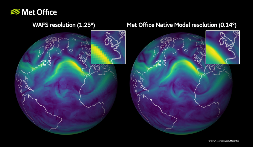
A comparison between a standard aviation forecast and a high-resolution forecast.
What is high-resolution weather data?
Weather data is used in flight planning to optimise the timing, efficiency and safety of a flight. The more accurate the weather data available, the greater the efficiencies for the airline.
The current World Area Forecast System (WAFS) dataset provided by the Met Office and NOAA, is required by ICAO, to have a resolution on 1.25 degrees, which is approximately 9 minutes of flying time between each wind forecast point. However, the base data generated at the UK Met Office is at a resolution of 0.14 degrees, which is downscaled for WAFS. This base data reduces flying time to under a minute between each wind forecast point.
With high-resolution weather the amount of errors between what has been forecast and what is happening is reduced, ultimately building up a much clearer picture of the weather along an aircraft’s planned flight path.
Contact the Met Office
If you would like to speak with one of Met Offices Aviation Team, email aviation@metoffice.gov.uk or to read more about their work in aviation, please visit their website.

